This post will be written according to my memory as I hadn’t brought any means of taking notes, so don’t expect too many details.
All lunches were 3-course dinners cooked on location, so the porters set up the dinner and kitchen tent at the lunch location to feed us, after which they took it all down again and continued to the location where we were to have dinner and stay the night. The dinners were “only” two courses. We were 15 tourists, 7 couples and me. This meant that I had my tent to myself, unfortunately the one-man tent was not the longest, so when stretching I hit my head and feet against the tent’s walls.
From the entrance of the Inca Trail where we were checked in, we had an app. 6 hours long walk to the first camp at Wayllabamba, at 2980m. It was quite an easy walk, not much climbing. We had a short distance at one point where we climbed a couple of hundred of meters, but apart from that the walk was quite eventless. At the lunch location a cow was literally staring at us – if we had had beef for lunch I would have started to become paranoid.
Second day was the absolute hardest of the four days. Got up at 0600 and around 1½ hours later we left camp. We were to climb the tallest point on the trek – Dead Woman’s Pass at 4201m. Our guide, Fernando, informed us that on the way up to the top point there would be two sites where we would be able to take breaks (longer relaxed breaks than just stopping up on the path). First site would be at 3300m and the next would be at 3800m. For each of the stretches he said it would take app. 2 hours, plus 1½ hours on the other side to get to our camp which was at 3600m. This would both be our lunch and dinner camp, so no more walking after lunch. We later found out that was a very good thing… Personal times on the four stretches; 1:10, 1:20, 1:20 (the record in the group was 1:00!) and 1:00, respectively. The complete distance that day was app. 8km, where probably 1½-2 of them were downwards after the top. Simple math will tell the average steepness of the day, though the steepness was much higher the second half between the second break and the top. No wonder the pass is called Dead Woman’s Pass – you feel like one when arriving…
Third day started with a climb to 3780m at a Inca ruin overlooking our camp. The 200m climb was done in a couple of hours, and coming over the ridge we got a beautiful view of ice and snow covered mountains in the distance with clouds surrounding them. From then on there was quite a steep descent to 3500m, after which we continued our walk a couple of hours through the cloud forest; a forest/jungle environment with plenty of fauna. Unfortunately the forest lived up to its name; the view was completely ruined by thick clouds 50m from the path. The path followed the sides of the mountains, and there was nothing but the width of the path – several places there was a literal 90 degree edge down where you couldn’t see what was growth and what was ground. We ended at our lunch site at 3600m, and afterwards we continued down. Here we walked down Gringo Killer – a row of very steep steps that took us down 1000m over a distance of 4-5km. We ended up at a ruin beautifully overlooking the mountains and valley. Just below, 20 minutes of walk later, we ended at our camp.
The fourth day started with a wakeup at 0340, so that we could queue up the final stretch when the check point opened at 0530. A brisk walk later, a couple of hours, in a gentle downwards direction, we ended up at the sun gate, overlooking Machu Picchu. An amazing sight – if the view hadn’t been obstructed by solid clouds. Being only 0730 in the morning there would still be plenty of time to get a good view. Reaching Machu Picchu the clouds slowly began scattering and you could start getting a view of the huge site. We had a couple of hours’ tour, after which we had free time until we had to catch a bus down to the train station that should take us back. During these two hours you realize two things: Firstly, no clouds can result in some great photos if you find the right location. Secondly, this is a huge tourist magnet. After 4 days with hard work you can’t help but feel just a little cheated by the fact that people who arrive in bus and train have all the same access possibilities as us. We would have liked to see that people who had walked the distance somehow had some advantages over the others, but alas.
Many people have asked me if it harder than Kilimanjaro. Simple answer; no. It’s much more scenic, though. The second day is slightly harder than the first two days on Kili (probably harder than the four first days), but on Kili you have four days that are almost as hard, followed by a night that is much harder. You don’t ascend as fast on Kili as on the second day, but the overall difficulty is still much higher. But if you have done the Inca Trail and want a new challenge, I can highly recommend the 6-day Machame Route on Kili.
Now sitting in Cuzco, and going to the Amazon tomorrow morning to stay there for 2 nights after which I go back to Lima and home. Four people from the Inca Trail group will also be going.
 The "before" photo at the start of the trail.
 Standing at 4200 meters. Not all were present as they were still up to 1 hour away, and it was getting too chilly to wait for all (the clouds were rolling in).
 Standing at the Sun Gate, getting first view of Machu Picchu. Oh... wait...
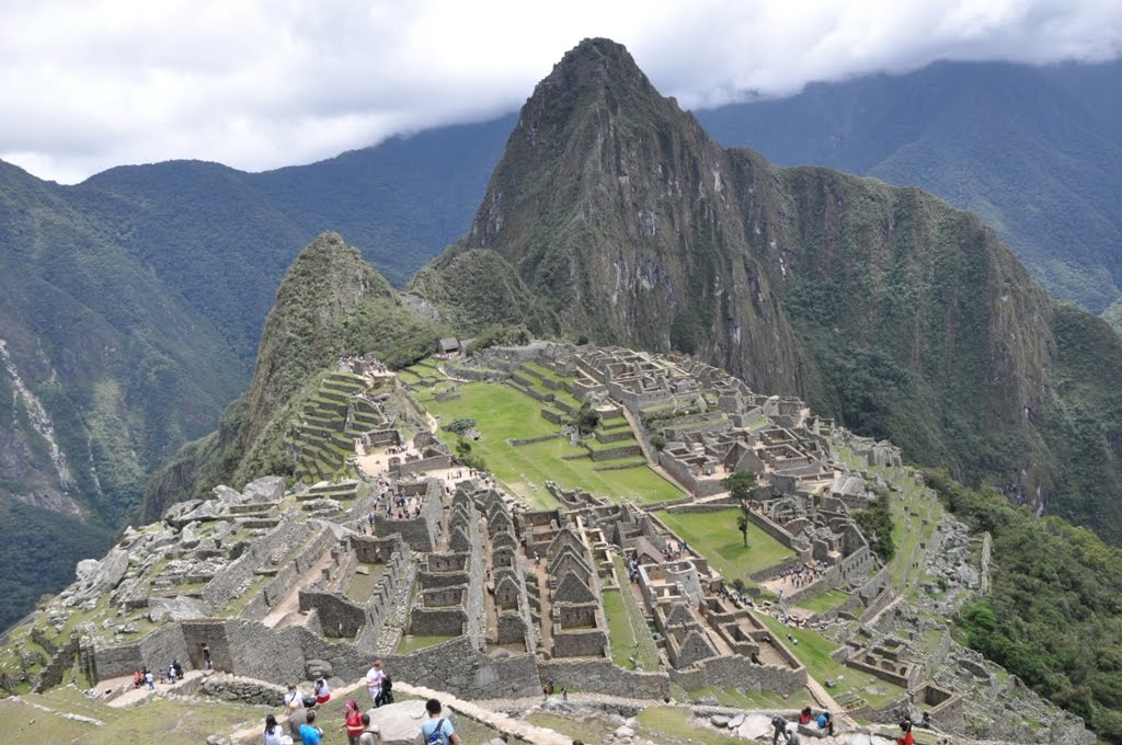 Machu Picchu, well worth the walk.
 And Machu Picchu as a panorama shot.
No comments:
Post a Comment