Having informed my guide last night that I was approved to leave from the morning she picked me up at the hotel at 0900 and after the usual formalities we quickly got down to business. We have 5 days with a flexible schedule: the overall plan is to visit locations on the islands Vágar, Streymoy, Eysturoy, Bordoy and Kalsoy, but the order will be set depending on the weather.
We started off by heading towards Vágar, the island where among other the airport is located, but before long the guide pulled over at a viewpoint overlooking Norðradalur and Koltur, the island just off the coast.

The first view of the trip. Norðradalur can just be seen nestled in near the water.
Driving through the deep tunnel to Vágar with 80m of water and 30m of rock above us we came up onto the island and headed towards the town of Sandavágur which we passed through, and on the other side we had a clear view of Trøllkonufingur (Troll wife’s/woman’s finger), a tall pointy rock just off of the coast’s rockface.

Trøllkonufingur.
A short walk back to the car we continued on to Miðvágurt where we parked right outside of the town and walked the 3-4 km along Sørvágsvatn that brought us out to the coast. Sørvágsvatn is the small lake close to the airport that is known for being elevated above sea level and only separated by rock and a waterfall. The weather had improved throughout the morning so standing at the tall rocks at the sea and enjoying the views it was the perfect place to enjoy our sandwiches for lunch. I also didn’t hurt we were the only ones there. From here you could see Streymoy, Koltur, Hestur and Sandoy, and as visibility slowly improved while we were there we also managed to get a glimpse of Suðuroy. The birdlife out here was mostly various gulls and fulmars.

Sørvágsvatn seen above the ocean.
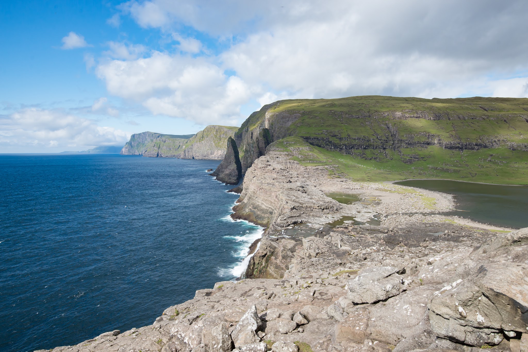
Sørvágsvatn can just be seen to the right, with a waterfall (hidden from this angle by the rocks) into the sea.

A bit of wildlife showed itself, here the always beautiful gannet.
We continued to Gasadalur, a small town of now 11 all-year residents, where we met a guy who was working on bringing back and breeding the Faroese chicken. The chicken was gone from the Faroe Islands but as Iceland had their own chickens he went there and brought some back to the Faroe Islands. These chickens are known as Icelandic chickens, but as they are genetically identical with the former Faroese chicken – voila! Faroese chickens were back on the Faroe Islands! What separates the Faroese chickens from the ordinary ones are primarily that they are much hardier and handle life in a much more exposed environment that the Faroe Islands is. The waterfall seen outside town was the one that I spotted on my way to Mykines last year. The tunned that we had to go through to get to the town was built in 2006 – before that that had goods sailed to a small dock, and if you didn’t want to sail you could walk across the mountain instead. They had hoped building the tunnel would make people move into the town, but instead the population dropped from 17 to 11. There are still vacation houses here, though, so there are often more than just the 11 around.

Gasadalur.
On the way back we stopped shortly in Bøur just on the other side of the tunnel before returning to Torshavn, ending the day.
I must say, though, that we have had surprisingly good weather today, especially considering where we are. Sunny and a bit clouded and at times barely any wind. It was only at Sørvágsvatn we really had wind, but we were fairly exposed there. It was an amazing start of the tour. Dinner was had at Etika, Torshavn’s amazing sushi restaurant. That salmon… Yum!
No comments:
Post a Comment